

Table of Contents
A powerful wind circulation high above the Arctic known as the polar vortex has weakened and shifted position unusually early in November. While such disruptions happen during winter, scientists report that an event occurring this early is unprecedented in modern observations and could disrupt current seasonal forecasts.
Understanding the Polar Vortex
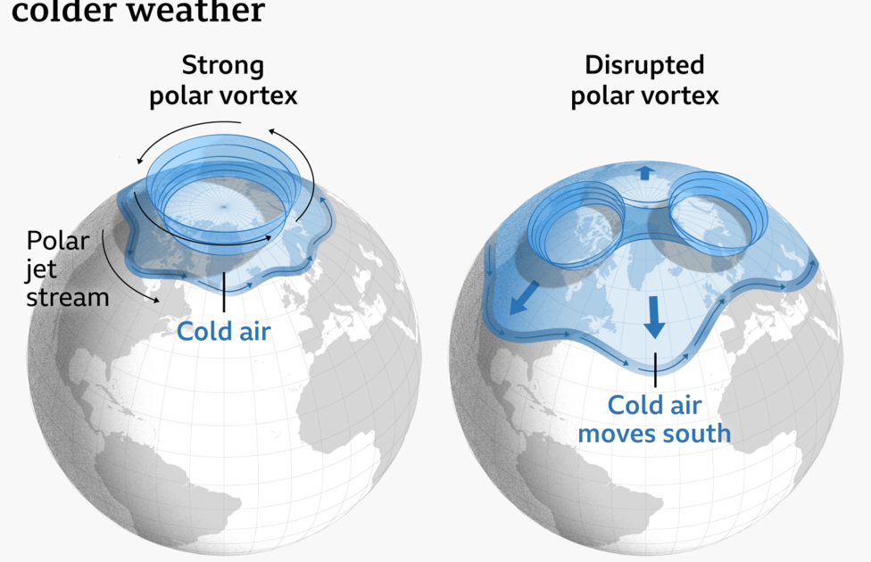
The polar vortex forms every autumn as temperatures drop in the Arctic, generating strong westerly winds in the stratosphere between 10 and 30 miles above the Earth’s surface that trap the coldest air near the pole. Atmospheric disturbances can trigger warming in the upper air, weakening the vortex winds in what is called a sudden stratospheric warming (SSW), which can eventually reverse the westerlies into easterly winds.
These atmospheric changes can shift the position of the jet stream in the following weeks, creating a blocked weather pattern that brings drier conditions and colder northerly or eastern winds carrying Arctic air. This process also increases the possibility of snowfall, particularly across the eastern UK.
Uncharted Territory and El Niño
Most SSW events usually occur from mid-winter onward, but current forecasts indicate a dramatic weakening and a potential reversal of the vortex winds by mid-November after the vortex stretched and briefly split into two smaller circulations. Jeff Knight, lead climate scientist from the Met Office, told BBC News that this appears to be the earliest event on record across 75 years of observations, with experts agreeing it is highly unusual. The previous earliest major SSW events occurred on 28 November in 1969 and 2025.
The exact cause of such an early event remains unclear, though it could stem from normal weather variability. While a normal El Niño year typically weakens the polar vortex toward the end of winter through Pacific Ocean warming and atmospheric energy pulses known as planetary waves, the current record El Niño takes scientists into uncharted territory. Knight stated that while El Niño may have helped load the dice for this event, the rarity means there is insufficient evidence to definitively link strong El Niño conditions to an early SSW onset.
Potential UK Weather Impacts
Long-range Met Office forecasts originally indicated a stormy start to winter followed by a colder spell, aligning with typical El Niño expectations, but this early SSW event caught meteorologists by surprise. Professor Andrew Charlton-Perez, a meteorologist at the University of Reading, told BBC News that while the typical response to an SSW involves colder and drier conditions over Europe and the UK, the unprecedented timing makes it harder to anticipate a cold spell.
The Arctic is not yet as cold as it becomes later in the season, and the polar vortex has only recently developed, meaning any influence on weather patterns could prove weaker than a mid-winter disruption. Consequently, cold and snowy weather for the UK is far from guaranteed.
Drought Concerns Remain Priority
Long-term forecasts rely on large-scale climate signals like the exceptionally strong El Niño, which has pointed toward a stormy autumn and early winter followed by potentially colder and drier conditions from January. However, this early polar vortex disruption presents a situation with few modern comparisons.
For Charlton-Perez, speaking to BBC News, the concerning aspect would be if the event brings the typical drier weather pattern and lack of rain associated with sudden stratospheric warming over the coming months. With large parts of England and Wales still experiencing drought conditions, experts emphasize that a wetter winter is required to replenish extremely low reservoir levels.
Experts stress that it remains too recent and uncertain to determine whether the polar vortex changes will ultimately alter the broader winter outlook.